1. What is topography?
Topography is the mapping of elevation starting from above sea level or below sea level.
2. What does a topographic map tell you, that other maps can't?
A topographic map can tell us the elevation of a location that other maps can't.
3. Who might use a topographic 9and why)?
People who might use a topographic map are geologists, hikers, mountain climbers, pilots, fire fighters, and marine biologist.
Define the following:
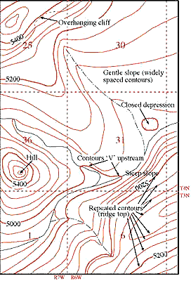
Elevation: It is the height of a place relative to a reference height.
Contour Lines: A line connecting points that the same elevation.
Contour Interval: The difference in elevation between two adjacent contour lines.
Depression Contour: Contour lines indicating a downward slope (drawn with hatch-marks).
Practice Questions:
1. Which of the topographic maps shows two peaks?
C
Which side has higher elevation?
The left side does.
2. Which topographic map shows the steepest cliff?
B
Where is it?
It is on the right side.
3. Can you tell the elevation of the topographic feature in plot b exactly? If so what is the elevation, if not, why and what would be your closest guess?
No, because we don't know the elevation.
4. Which topographic map has a contour interval of 50 feet?
A
5. Which of the topographic maps depicts a canyon, or depression?
B
